The National Weather Service in Tulsa is predicting some possible severe weather on Tuesday evening.
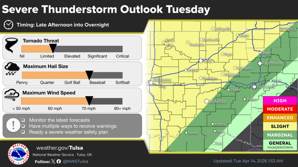
A Slight Risk for severe thunderstorms exists from Tuesday afternoon into Tuesday evening for parts of eastern Oklahoma and northwest Arkansas to the west of a line from near Rogers to McAlester, according to the NWS.
A Marginal Risk exists to the east of the Slight Risk area, extending from Ozark to Hugo. Large hail the size of a tennis ball, damaging winds of up to 70 mph, and a limited threat for tornadoes are the main threats.

The NWS says late afternoon and evening time frames are most favored for severe weather on Tuesday.
Current data indicate the severe weather threat will end west of a line from Vinita to Henryetta by midnight Tuesday night and by 2 am early Wednesday morning eastward to a Huntsville to Antlers line, the NWS says.
The National Weather Service says a Slight Risk of severe thunderstorms remains forecast for Wednesday into Wednesday night for parts of eastern Oklahoma and northwest Arkansas to the west of a line from Eureka Springs to Wilburton.
A Marginal Risk exists to the east of the Slight Risk area across the rest of eastern Oklahoma and northwest and west central Arkansas. Large hail the size of a tennis ball, damaging winds of up to 70 mph, and a limited threat for tornadoes are the primary threats.